
The tuk-tuk driver in Haputale shook his head when the backpacker showed him the map. “Belihuloya? Today? Sir, which way?”
That’s the real question. There are two ways to get from Haputale down to Belihuloya, and they feel like two different trips. One is a road. The other is a rough track that drops through tea country, forest edge and sleepy villages, and ends at a waterfall. I’ll walk you through both, and tell you which one I’d pick.
Two Ways Down the Mountain
Let’s be clear about the choice before we get into the detail.
- The road option: You stay on paved roads and loop around the long way. It works fine for getting from A to B, and buses and taxis do it every day. But you’re mostly looking at the back of the vehicle in front, and the highlands you came to see slide past in a blur.
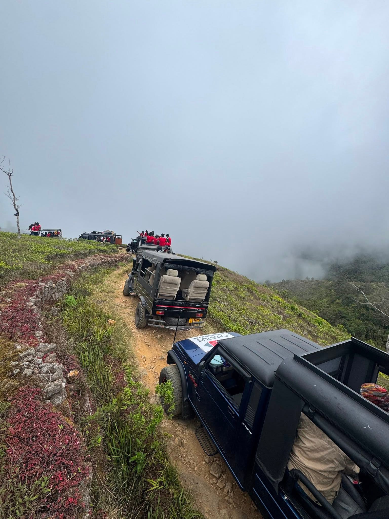
- The jeep track option: This is the Haputale to Belihuloya route via the Devil’s Staircase. It’s slower, rougher and a lot more interesting. You can’t do it in a normal car (I covered why a normal car won't make it down Devil's Staircase in my last post), but a 4x4 jeep with low-range gear handles it comfortably.
I’m biased, obviously. But I’ve done both, and I’d choose the track every time unless the weather turned.
Route Quick-Facts
| Detail | Jeep track | Paved road |
|---|---|---|
| Feel | Scenic, bumpy, slow | Smooth, direct, repetitive |
| Typical time | 3–4 hours with stops | Often 2+ hours without stops |
| Vehicle needed | 4x4 jeep, low-range gear | Car, tuk-tuk, bus |
| Photo stops | Plenty (Baker’s Bend and more) | Few safe places to pull over |
| Waterfall access | Bambarakanda can be added | Possible, but a separate detour |
| Best for | Adventure travelers, couples, curious families | Travelers short on time |
| Weather sensitivity | High (mist, rain, slick clay) | Low |
The Start: Haputale and Kalupahana
Most mornings begin the same way. We meet guests at their guesthouse in Haputale, or at Kalupahana if they’re already on that side. Tea in hand, a quick look at the sky, and then we set off.
The first stretch runs through working tea estates. In the early light, pluckers are already in the rows, baskets on their backs, moving faster than you’d believe. We slow right down passing them. It’s their workplace, not a film set, and a wave goes a long way.
Then the track starts to change. The surface roughens, the first hairpins arrive, and you feel the jeep settle into low gear. This is where the staircase begins.
Baker’s Bend: The Stop Nobody Skips
About a third of the way along, the track swings round a sharp curve with a wide open drop on one side. That’s Baker’s Bend.
On a clear morning you can see a long way across the valley, layers of ridges fading into pale blue. We always stop here. Not because we have to, but because every guest asks us to stop the moment they see it.
A few honest tips for this spot:
- Stay behind the edge: It’s a long way down, and the ground at the lip is loose.
- Go early: By late morning the mist often fills the valley, and the view vanishes.
- Take your photos, then just look: The camera never captures how far it goes.
The Hairpins and the Descent
Past Baker’s Bend the track really starts to drop. The bends stack up, one under the other, and the gravel gets looser.
This is the section where a driver’s experience matters. We use low-range gear so the engine holds the jeep back on the way down, and we keep off the brakes as much as possible. We read the V-shaped drainage cuts across the track and take each one at an angle. We know which bends need a three-point turn and which don’t.
For guests, the experience is simple: hold on, relax, and enjoy the ride. You don’t need to know any of this. That’s the point of having a local at the wheel.
What it feels like
- Cooler, damp air at the top
- Warmer and heavier air as you lose height
- Dust on dry days, slick red clay after rain
- Birdsong in the forest sections, then near silence in the open ones
Time for a Swim? Bambarakanda Waterfall
Near the end of the route, there’s the option to add Bambarakanda Waterfall. It’s the tallest waterfall in Sri Lanka, and it’s worth the extra stop even if you only have a short window.
Depending on the season, the flow ranges from a thin white ribbon to a heavy roar. Either way, it’s a good place to cool off, stretch your legs and eat something. We usually let guests take an hour here if they want it.
Quick safety note: Rocks around any waterfall are slippery, and water levels can rise quickly after rain upstream. Follow your driver’s advice about where it’s safe to swim.
Want Us to Plan It Around You?
If this sounds like your kind of day, Haputale Skyline Tours runs private 4x4 Jeep Safaris on exactly this route. We offer pickup from Haputale, Belihuloya or Kalupahana, so you can go in either direction. Our drivers know this track well, and the stops are flexible. Want a long breakfast at Baker’s Bend? A swim at Bambarakanda? A quiet drive with no schedule? Tell us and we’ll shape it.
There’s no pressure to decide today. Ask us anything about timing, weather or pricing, and we’ll answer honestly.
Which Way Should You Go?
Here’s how I’d decide:
Take the jeep track if:
- You’ve got half a day and enjoy scenery over speed
- You’re traveling with a partner, friends or older kids who handle bumps well
- You want photo stops and a waterfall swim
- The forecast looks dry
Take the road if:
- You’re catching a tight onward connection
- You get severe motion sickness
- It’s been raining heavily for days
- You’re carrying a lot of heavy luggage and no private transfer
I’d rather tell you the road is the better choice for your day than put you on a track that doesn’t suit it.
What to Bring
- A light rain jacket (mist arrives fast after late morning)
- Closed shoes with grip
- Sunscreen and a hat for the clear hours
- Swimwear and a small towel if you’re adding the waterfall
- Water and snacks
- Cash for small village stops
- Motion sickness tablets if you need them
Common Mistakes We See
- Starting too late: The mist and the afternoon cloud can swallow the views.
- Relying on offline maps alone: The track isn’t always marked clearly, and signal drops out.
- Wearing sandals: Wet clay and loose gravel don’t mix with flip-flops.
- Rushing: This route rewards slow travel. Trying to squeeze it into a short window defeats the point.
Frequently Asked Questions
How do you get from Haputale to Belihuloya?
You can take the paved roads by bus, taxi or private car, or drive the rougher jeep track via the Devil’s Staircase. The track needs a 4x4 with low-range gear and an experienced driver.
How long does the Haputale to Belihuloya jeep ride take?
Plan for roughly 3–4 hours including photo stops at places like Baker’s Bend. Add extra time if you want to swim at Bambarakanda Waterfall.
Is the Haputale to Belihuloya jeep route safe?
It’s safe with an experienced local driver and a properly maintained 4x4, especially if you start early and avoid heavy-rain days. Self-driving in a normal car isn’t recommended because of loose gravel, steep descents and drainage cuts.
Can I start in Belihuloya instead of Haputale?
Yes. With Haputale Skyline Tours you can be picked up from Haputale, Belihuloya or Kalupahana, and we’ll run the route in whichever direction suits your plans.